On the evening of April 14th, 1912, the HMS Titanic was making her way from Southampton to New York. Steaming off the coast of Nova Scotia she collided with an Iceberg at 11:40 pm. By 2:20 am after taking on water along her starboard side, the “unsinkable” vessel foundered, broke apart, and sank with over a thousand souls onboard. In response to this tragedy the International Ice Patrol (IIP) was set up to monitor the flow of icebergs within shipping lanes between Europe, Canada and the United States. Iceberg Alley
Greenland’s ice sheet contains almost 10% of the earth’s glacial ice. Breaking off the western shelf into Baffin Bay, massive pillars and smaller shards follow the Labrador Current along the northern coast of Canada reaching the Gulf Stream south of Halifax. This stretch has become known as Iceberg Alley. Between St. John’s, Newfoundland and about 400 miles south of Nova Scotia, icebergs intersect the busiest stretch of ocean in the Western Hemisphere, the Great Circle route between Europe and the United States. It was in this area 105 years ago that the Titanic met her doom, a tragedy which the IIP has been on guard against since 1913.
The International Ice Patrol
Headquartered in New London, CT, today’s IIP is an alliance of 17 nations spearheaded by the U.S. Coast Guard. Based in St. John’s, the air reconnaissance unit maintains a fleet of four HC-130 aircraft which patrol the waters off Canada and the United States monitoring icebergs which intersect major shipping lanes. Tasked with identifying the largest and most hazardous formations, the planes drop buoys to track their movement, reporting daily as ice drifts further south. Cmdr. Gabrielle McGrath who heads up the reconnaissance unit noted that within the last 104 years since its inception all vessels which heeded IIP warnings have made safe passage through the region.
Ice looms on the horizon
In a recent interview Cmdr. McGrath indicated the operations center is handling a fourth straight year of heavy ice flows. They typically see around 212 icebergs at this time, but that number has jumped to 660. In just one week reports went from 37 to 455 hazards. So far this April the Canadian Coast Guard has responded to 85 distress calls from ships in Iceberg Alley as ice continues to impact regional fishing.
St. John’s under siege
Oceanex which operates general cargo and refrigerated service within the Canadian Maritimes has been forced to reduce speed to 3 to 4 knots as they return to their home port in St. John’s. This has added a day to the transit time and costly repairs to one vessel which hit a chunk of ice. The SeaRose, a floating drill rig off the coast of Labrador, had a near brush with an iceberg this week which almost shut down operations. Husky Energy Corp was forced to shut down their Henry Goodrich platform and tow it out of the path of impending ice while they decide future plans for the rig. IcebergFinder, a website sponsored by Newfoundland and Labrador, tracks and reports regional ice flows noting that 90% of the iceberg is underwater posing the greatest risk to mariners.
The Size of the Problem
Scientists agree while all icebergs are dangerous, smaller ones which are not as easily detected on radar are harder to avoid. The smallest called growlers and bergy bits are mostly under water. They’re about the size of a small ship and when submerged can cause a significant amount of damage to ocean going vessels.
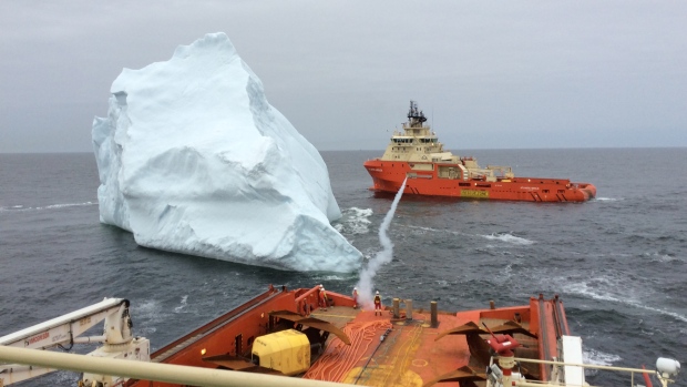
Moments after a rope line was shot between two vessels so they could move in tandem to guide the iceberg away. (J.D. Irving Ltd.) Changing Course
Ice is beginning to choke major trade routes causing some carriers to rethink their operations. More than 400 icebergs have drifted into the shipping lanes forcing vessels to reduce speed and or divert hundreds of miles to avoid danger. Aslak Ross, head of Marine Standards for Maersk Lines, noted that they operate their ships with the highest standards of safety. Avoiding areas of iceberg activity is something which needs to be considered for safe navigation, he said. Uncommon prevailing winds continue to drive ice further south into the Atlantic in what will become a record season. This week alone the International Ice Patrol identified 382 icebergs and peak season is not until May and June. Could this year’s level of activity cause a major shift in how freight moves across the North Atlantic? Changing port rotations to take vessels further south? Will transit times significantly increase or may we see surcharges imposed to offset higher operating costs?
What new challenges to navigation will the next few months bring to Iceberg Alley?