
US funds help La’s Water Institute develop early warning shoaling along the Lower Mississippi
by Stas Margaronis Sep 26, 2022
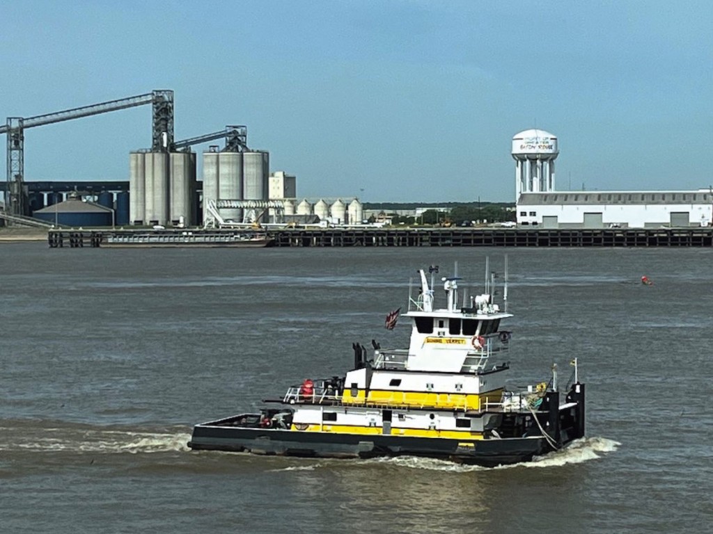
The Water Institute of the Gulf is harvesting depth sounding data from a fleet of tugs working in Louisiana’s stretch of the Mississippi River so as to develop an early warning system that anticipates shoaling problems for river shipping and ports.
With grants from the U.S. Department of Commerce’s Economic Development Agency, the State of Louisiana, Port of New Orleans, Port of South Louisiana and other partners, the Institute will develop a Lower Mississippi River SmartPort & Resilience Center (SmartPort).
The Institute says the SmartPort project will “forecast shoaling at port facilities along the Mississippi River, improve port operations and benefit a variety of stakeholders who need to understand how sediment builds up in the Mississippi River” and “will be coupled with a suite of weather, river, and road traffic analytics to improve efficiency and help the region’s ports become more resilient in the face of future natural disasters and economic shocks.”
In an interview, Bobby Landry, Senior Advisor Water Institute of the Gulf, told AJOT: “The purpose of the project is to provide a good predictive model for what’s going on the Mississippi River. To some extent we have better data about the surface of the Moon than we do about the riverbed of the Mississippi River.”

Landry added: “We don’t have sufficient data along the tributaries and at the ports and especially at the smaller ports. Currently, we cannot predict or anticipate a problem. I was very surprised to find that a lot of tugs did not carry sounding equipment. It is important that I emphasize at this point our data collection and analyzation are not designed for navigation but will certainly aid in commercial concerns along the River.”
Previously, Landry worked at the Port of New Orleans where since 1989 he served as the Director of Marketing, Senior Manager of Operations, and most recently as Vice President and Chief Commercial Officer.
Landry said the ports need more data about river conditions: “During my time at the Port of New Orleans, we would hear from the pilots when they were berthing a ship that they discovered a problem with the draft. It happened at the Napoleon Avenue Container Terminal.”
Landry said the Water Institute project will help anticipate such problems in advance so dredging resources can be deployed.
Exporters also see the value: “We spoke to Cargill and asked them if they thought having shoaling information 30 days in advance would be useful and they said it would make all the difference in the world.”
The reason is that Cargill could ship its grain exports down the Mississippi River to Gulf Coast ports with the updated draft data at various river locations. Cargill would benefit by deploying its barges more efficiently.
Landry said the research “project started off with a few tugboats providing sounding data back in 2021 … and has grown to between 50-75 tugboats today … (and) we are looking to include cruise ships. Now that data is compiled according to time, location, and depth and stored on the cloud so we can develop trend lines. We started in the summer of 2021 with 2-3 tugs and expect to conclude our research in 2023 with over 75 vessels providing sounding data.”
According to the Water Institute one of the project supporters is the Port of South Louisiana whose CEO Paul Matthews said: “As one of America’s largest tonnage ports, the Port of South Louisiana is focused on serving the maritime needs of our resident industries. Partnering with The Water Institute and Louisiana Economic Development will allow us to apply crowd sourcing data and cutting-edge scientific analysis to a concern for vessel operators and shippers not only on the Mississippi River, but also around the world … Our better understanding of shoaling, and our ability to provide more accurate, timely and precise predictive elements to shoaling forecasts, will enhance the safety and efficiency of all the Port’s maritime endeavors.”
The Water Institute website provided the following background:
- Along with its advanced analytics, customized ‘Resilience Dashboards’ will be created and maintained for the Ports of Lake Providence, Madison, Vidalia, Baton Rouge, South Louisiana, New Orleans, St. Bernard, and Plaquemines.
- These tools will assist in tracking progress and adaptively managing port resilience. Along with the digital platform, “this $3 million investment will culminate in a new SmartPort facility to be housed on The Water Campus in Baton Rouge.”
- The facility will serve as a specialized emergency operation center for ports when needed and a place for the exchange of information during non-emergency times.
- The Institute worked closely with the Port of New Orleans, IBM, and Crescent Towing in developing tools that harvested and validated depth data to inform port dredging operations. Through SmartPort, “the Institute will be able to scale this successful pilot project along the Lower Mississippi River from North Louisiana to the Gulf of Mexico.”
Stas Margaronis
Upcoming Events
Latest Print Edition:
- Georgia Ports and Trade
- Pacific Coast Ports and Trade
- Temperature-Controlled Logistics
- Breakbulk Quarterly
© Copyright 1999–2024 American Journal of Transportation. All Rights Reserved